
Designing TransLink’s RapidBus program
February 28, 2022
By Alice Zhao
Vancouver’s busiest bus routes have been enhanced.
Photos courtesy WSP in Canada.
TransLink’s RapidBus program, which aims to improve the frequency, speed and reliability of public transit across the Metro Vancouver region by extending the connectivity of the SkyTrain network, comprises more than 60 km of bus priority infrastructure, with more than 120 stops across 10 communities. It also involves another 40 km of improvements to existing transit corridors.
“The program plays an important part in connecting the region through high-quality bus service,” says Jeff Deby, TransLink’s manager for the program.
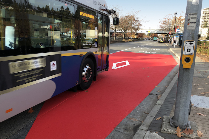
Specifically, RapidBus combines more frequent all-day service with fewer stops (each approximately 1 km apart), all-door boarding procedures for larger articulated buses, priority lanes and signals (e.g. additional turn restrictions), significantly increased shelter capacity in terminus areas and tactile surface walking indicators to help those with visual impairments more easily navigate the transit system, among other measures.
The bus corridors run through urban, suburban and highway environments—one design would not fit all.
Consulting firms WSP in Canada, Access Planning and Nelson\Nygaard worked from TransLink’s predetermined routes, general stop locations and service characteristics to complete the program’s planning, design and construction in less than two years, under an accelerated project delivery model. Co-ordinating input from local governments, TransLink and the Coast Mountain Bus Company (CMBC), the design team was responsible for analyzing traffic, identifying opportunities to reallocate road space for the bus priority infrastructure, designing and costing both preliminary concepts and detailed plans, supporting contractor procurement and providing engineering services throughout construction.
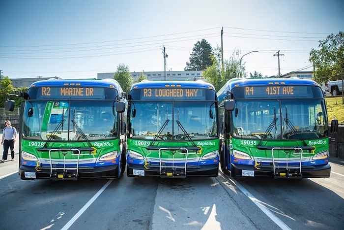
The project rolled out larger, articulated buses.
Gathering input
Working within constrained rights-of-way and a tight timeline, the team needed to direct design attention in a way that minimized conflicts with existing utilities and infrastructure. The RapidBus corridors run through dense urban, evolving suburban and regional highway environments, so one design would not fit all.
The team used a combination of data analysis, corridor-level traffic simulation, intersection-level micro-simulation and professional judgment, based on the conditions, risks and complexity at various locations. The focus was on determining the most feasible, cost-effective changes to the transportation network that would reduce delays for transit users. The team used PTV Vissim and Aimsun traffic modelling software, with visual simulation outputs built specifically for this project, to help determine the best design options.
The accelerated schedule was required to meet TransLink’s commitment to launch four of five RapidBus corridors in parallel by January 2020, followed shortly thereafter by the fifth. A 17-month construction period began in early 2019 and ended after the completion of all five corridors, i.e. in mid-2020.
Designs had to comply with each municipality’s standards.
The design team worked with 10 road authorities in the Metro Vancouver area, including the provincial ministry of transportation and infrastructure, and the University of British Columbia (UBC). Ongoing co-ordination during construction allowed for seamless corridor integration across a wide geography, where design efforts had to comply with each municipality’s standards.
The team also adapted quickly to evolving conditions on-site and engaged stakeholders in approving roadway, structural, electrical and utility design changes after in-house engineering analysis. The project had to accommodate, where possible, adjacent public and private-sector projects, including allowances for future roadside projects, such as local developments.
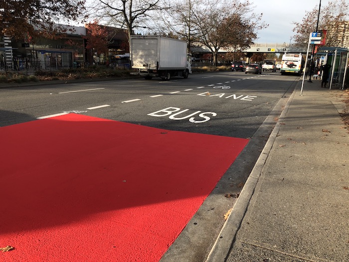
More efficient service is accomplished with priority lanes and fewer stops.
Reducing travel times
The new RapidBus corridors resulted in faster travel times, saving tens of thousands of person-delay-hours for all road users during peak periods. These savings were achieved through a diverse arrangement of transit priority measures, each tailored to suit local stakeholders’ preferences and tolerances.
The design team ran its model through various simulations, based on different scenarios for corridors on Marine-Main (using PTV Vissim), Lougheed (using Aimsun) and UBC/41 (using Trafficware‘s Synchro and Simtraffic, as well as for all the corridors). In total, the model predictions showed a reduction in trip time of 20% in comparison to conventional bus travel along the corridors, equivalent to saving 10 to 25 minutes.
The project also promotes active transportation.
While RapidBus is primarily a transit project, the corridors also help promote active transportation. The project has added 40 km of new and revitalized cyclist lanes within the 21 municipalities in Metro Vancouver, including new, modernized, fully illuminated multi-use pathways. The overall length of bikeways in the region tripled from 1,700 km in 2009 to 4,600 km in 2019 and the RapidBus project is an important contributor to this achievement.
The design team addressed immediate requirements to launch the new service in January 2020, while also planning for future incremental improvements to further upgrade the corridors during additional implementation phases to follow. The success of this project can be attributed in part to the extensive, complex multi-jurisdictional engagement co-ordinated by the consulting firms through all phases of planning and delivery.
Alice Zhao is an engineer-in-training (EIT) with WSP in Canada. For more information, visit www.wsp.com. This article originally appeared in the January/February 2022 issue of Canadian Consulting Engineer.