
Brought to you by GeoVerra
Technology and surveying: Providing access to information we never thought possible
June 1, 2023 in Engineering
By CCE
GeoVerra is delivering information more accurately and safer than ever before—all while saving time and money.
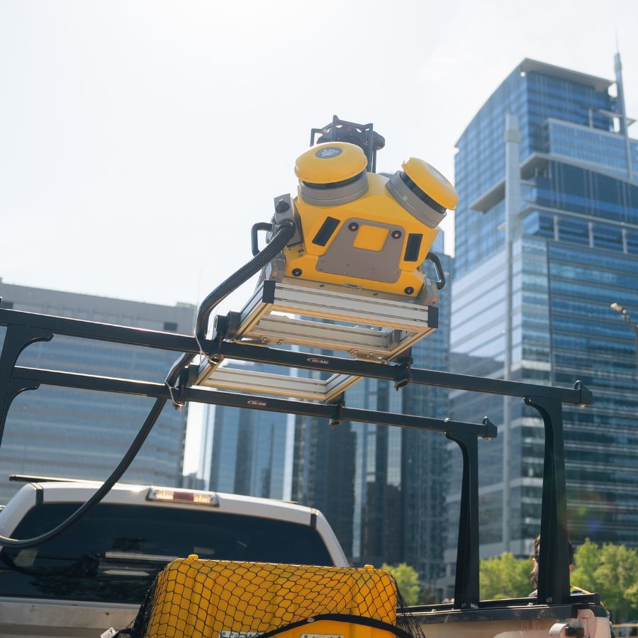 Photo courtesy GeoVerra.
 Photo courtesy GeoVerra.
Surveyors have always been in the business of data collection, but the technology we have access to now and the improvements we’re making in digital transformation give clients access to the information we never thought was possible.
For projects like highways, rail, facilities and large green energy initiatives, conventional surveying can be tedious. Boots on the ground can pose a serious challenge for crews to acquire precise measurements efficiently and safely, taking a lot of time and calling for large crews to get the job done.
While there’s a time and a place for traditional surveying, GeoVerra embraces technology to advance our industry and yours.
Sometimes, it means giving our boots a break.
New Standards
Mobile Mapping Systems (MMS) use an advanced laser affixed to a moving vehicle that scans its surroundings at 360 degrees. This technology measures objects by millions of points per second with centimetre accuracy, quickly collecting every visual component in diverse environments, including highways, urban streets, railways and pipeline routes. Clients can easily access this new class of data digitally, for a total immersive and accurate 3-D view of objects and surroundings for their project.
Technology is redefining major projects and radically changing the way our clients think about surveying. With improved safety, compressed schedules and reduced costs for some of the country’s largest infrastructure and energy projects, MMS is our standard for collecting spatial data.
In fact, GeoVerra’s teams were among the first to adopt mobile mapping technology. And GeoVerra was the first company in North America to receive Trimble’s MX50 with the AP60 GNSS-Inertial system, a MMS for surveying, engineering, asset management, documentation and mapping.
Alex Garcia, GeoVerra’s National Manager, Mobile Solutions, relies on MMS for the major projects he handles.
“The system collects the imagery and what we call ‘point cloud,’” he says. “That means the laser is spinning and collecting tiny dots that are literally three millimetres apart from each other. We take accuracy to the next level.”
The MMS Makeover
“Before MMS, it looked like this: the team assembles to the site and physically walks all day to collect data for only one of those components,” Garcia explains. “If more information was needed—say, specific powerline data—then the team would reassemble again for another day in the field, collect the information and take it back to the office.
“With mobile, it’s simple: the surveyor drives down the road, collecting 360-degree point cloud and images. From surface condition, facilities, assets and whatever else the client needs, we can collect everything with high precision—and it’s accomplished literally in a day, saving valuable time.”
In fact, Garcia’s team collected 350 kilometres’ worth of data for a client—with centimetres’ accuracy—in one day. That same result would require more than three months of boots-on-the-ground collection by a team of surveyors. On large projects, meeting or exceeding schedule expectations is critical.
Of course, increasing productivity at the expense of safety is not an option. Now we have fewer boots on the ground to get the job done, mitigating safety risks.
You’ve Got Data
So, after you’ve collected all of this great data through MMS, unmanned aerial vehicles (UAVs) or by another advanced tech survey means, what is the client going to do with it? Who’s going to see it? How do we make the most of it?
GeoVerra’s National Manager of GIS and in-house client portal champion, Cindy Genkin, answers these questions constantly. Using a geographic information system (GIS) that creates, manages, analyzes and maps all types of data, then crafting it into one seamless, tailored web portal, she helps make data more accessible to GeoVerra clients than ever before.
“We put information into one place so everyone can collaborate,” she says.
Cut the Cookie Cutter
These portals are powerful and meaningful, allowing clients to analyze massive amounts of information and make data-driven decisions for nearly every industry imaginable.
“Every portal is unique to our client, shaped to suit their goals,” explains Genkin. “That can include supplemental dashboards, still images, 360 panoramic images, 3-D models, documents, precise maps and so much more.”
By understanding, integrating and delivering data in an intuitive, visual way, teams can gain more insights, drive smarter operations and ultimately deliver a safer and more sustainable project and business.
Geomatics has always been ahead of the game in leveraging technology, but for years, it was only larger infrastructure projects with big budgets that could afford to pull information together in this way—until COVID.
“In the last two years, this interest has trickled down to every type of project,” says Genkin. “If there’s any element of dispersion, no matter the industry, clients want to be able to connect online.”
With people at home and major site restrictions, GeoVerra collected data and made sure everyone could see it, without anyone ever stepping foot on-site.
A perfect example is construction monitoring. Every so often, we’d scan the site with panoramic images. People could go in and see exactly what was happening, then compare it to the design files to ensure everything was on target. To think that was only ever done in-person … it’s opened up everyone’s eyes.
Real Life Results
When GeoVerra gets involved in a project early enough, we can help clients organize the data they have, identify what’s missing and design a way for the entire team to collaborate.
“It’s about creating one place where you can go and get an answer, without having to wait three hours for the person who knows that answer,” says Genkin.
It’s hard to attach a dollar amount to time saved with so many factors at play, but Genkin recalls gathering and displaying data from many different sites for one client.
“They said they saved $50,000 in one month,” she says.
GeoVerra delivers more information, better accuracy and increased safety, all while saving time and money.
Think MMS and data visualization can boost your project? Contact GeoVerra today.