
Technology: the Business of Reality Capture
June 26, 2015
By Daniel Chapek, IMAGINiT
For recording existing conditions, engineers can combine various new technologies to match their clients' needs.
Today’s reality capture technologies — like drones, high definition scanners and smart phone point cloud capture — are making it easier for civil and surveying firms to record existing conditions with higher accuracy and more information.
Not only does reality capture offer a better way to produce designs or inspect existing structures, but it also provides new business opportunities.
Making decisions about which technologies to acquire should be based on what you intend to pursue from a business standpoint. Which of your client sectors would benefit from the support of reality capture services? For each of the three stages involved, there are various technologies that can achieve similar, but not the same results.
Capture
High definition (or 3D) laser scanners and digital cameras using photogrammetry are the two main ways to capture terrain or built environment information digitally. Drones have made civil surveying safer and easier, and they can also carry cameras or scanners. Either method of reality capture results in a point cloud — laser in the case of scanning, and pixel mapping in the case of photogrammetry.
Photogrammetry combined with LiDAR can produce powerfully accurate models, so it is not always a case of “either/or.” A firm may benefit from both, depending on what they want to achieve. Some firms may even decide not to buy any equipment, but to focus rather on processing raw data supplied by a third party.
Processing
Point cloud data requires registering project coordinates; in an ideal world, it would be geo-coordinates. There are a number of ways to achieve this. Scanner manufacturers have proprietary software to get the data from the hardware into digital format. For example, Leica offers a product called Cyclone which registers data from each set-up or collection to form a single point cloud environment using targets, models or the collected point clouds themselves.
Photogrammetric camera manufacturers offer their own post-processing software like Pix4D which will process photos from anywhere and create a platform-agnostic collection of images. Autodesk has a product called ReCap (short for reality capture). ReCap is free, and the ReCap 360 Ultimate supports scan-to-scan registration and survey control verification. Both support any type of scanner.
Many variables affect how the engineer approaches the capture and processing stages. Pre-planning is imperative. What type of data, and at what resolution, does your client require? Resolution is a critical question because point cloud files for high-resolution models are colossal. Due to their size, they can bog down computing equipment and cause problems with file sharing and online collaboration.
The important question is: What is the end deliverable? Is it a BIM? A terrain model for Civil 3D? A Navisworks file? A file for plant design?
Modelling
Once the point cloud has been registered to reference points, geometry recognition tools help you identify the points that make up piping, curbs, pedestals, or other structures. These programs allow designers to create solid models, which can then be imported into Civil 3D, Navisworks, or other 3D modelling software.
The construction industry often uses Navisworks for verification and inspection because it allows engineers to compare the design against the post-construction built reality. In this case, surveyors can collect the data using a Leica scanner, register it and process it with Cyclone. Then, a design engineer can use Cloudworx for Navisworks to bring the point cloud directly into Navisworks for detecting clashes or to ensure proper clearances.
If technicians in the field used a Leica scanner to produce the point cloud and wanted to turn over a model for AutoCAD, they might use Cloudworx for AutoCAD, or equally they could use ReCap. If delivering a BIM, a product called IMAGINiT’s Scan to BIM helps to automate the process of creating the model from the point cloud.
The point here is that depending on their business goals, a firm will select different pieces of equipment and software. By working backward from the most typical deliverable for clients, engineers can clarify which technologies work best together and which will net the biggest return on investment.
Daniel Chapek is manager of reality capture solutions for IMAGINiT Technologies, with more than a decade working with infrastructure technology. E-mail dchapek@rand.com, or visit www.imaginit.com/RealityCapture.
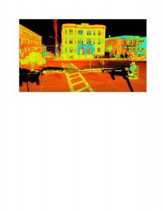
Point cloud image collected by a high-definition scanner. Image courtesy Samiotes Consultants.